Chapter 3
Latitude, Longitude and Time
THE EARTH is nearly a sphere. It is because of the fact that the equatorial radius and the polar radius of the earth is not the same. The rotation of the earth over its axis produces bulging at the equator. Hence, the actual shape resembles that of an oblate spheroid. The shape of the earth presents some difficulties in positioning its surface features, as there is no point of reference from which to measure the relative positions of other points. Hence, a network of imaginary lines is drawn on a globe or a map to locate various places. Let us find out what are these lines and how are they drawn.
The spinning of the earth on its axis from west to east provides two natural points of reference, i.e. North and South Poles. They form the basis for the geographical grid. A network of intersecting lines is drawn for the purpose of fixing the locations of different features. The grid consists of two sets of horizontal and vertical lines, which are called parallels of latitudes and the meridians of longitudes.
Horizontal lines are drawn parallel to each other in east-west direction. The line drawn midway between the North Pole and the South Pole is called the equator. It is the largest circle and divides the globe into two equal halves. It is also called a great circle. All the other parallels get smaller in size, in proportion to their distance from the equator towards the poles and divide the earth into two unequal halves, also referred to as the small circles. These imaginary lines running east-west are commonly known as the parallels of latitude.
The vertical lines running north-south, join the two poles. They are called the meridians of longitude. They are spaced farthest apart at the equator and converge at a point at each pole.
The latitudes and longitudes are commonly referred to as geographical coordinates as they provide systematic network of lines upon which the position of various surface features of the earth, can be represented. With the help of these coordinates, location, distance and direction of various points can be easily determined.
Although an infinite number of parallels and meridians may be drawn on a globe, only a selected number of them are usually drawn on a map. Latitudes and longitudes are measured in degrees ($^\circ$) because they represent angular distances. Each degree is further divided into 60 minutes ($'$) and each minute into 60 seconds ($''$).
Glossary
Parallels of Latitude : The parallels of latitude refer to the angular distance, in degrees, minutes and seconds of a point north or south of the Equator. Lines of latitude are often referred to as parallels.
Meridians of Longitude : The meridians of longitude refer to the angular distance, in degrees, minutes, and seconds, of a point east or west of the Prime (Greenwich) Meridian. Lines of longitude are often referred to as meridians.
PARALLELS OF LATITUDES
The latitude of a place on the earth's surface is its distance north or south of the equator, measured along the meridian of that place as an angle from the centre of the earth. Lines joining places with the same latitudes are called parallels. The value of equator is $0^\circ$ and the latitude of the poles are $90^\circ \mathrm{N}$ and $90^\circ \mathrm{S}$ (Fig. 3.1 on the next page). If parallels of latitude are drawn at an interval of one degree, there will be 89 parallels in the northern and the southern hemispheres each. The total number of parallels thus drawn, including the equator, will be 179. Depending upon the location of a feature or a place north or south of the equator, the letter N or S is written along with the value of the latitude.
If the earth were a perfect sphere, the length of $1^\circ$ of latitude (a one degree arc of a meridian) would be a constant value, i.e. $111~\mathrm{km}$ everywhere on the earth. This length is almost the same as that of a degree of longitude at the equator. But to be precise, a degree of latitude changes slightly in length from the equator to the poles. While at the equator, it is $110.6 \mathrm{km}$ at the poles, it is $111.7 \mathrm{km}$. Latitude of a place may be determined with the help of the altitude of the sun or the Pole Star.
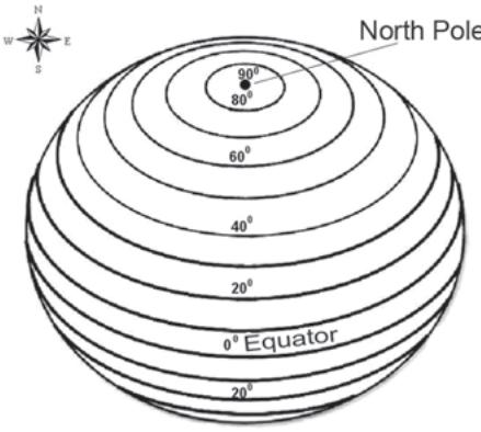
Figure 3.1 Parallels of Latitudes
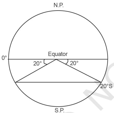
Figure 3.2 Drawing of Parallels of Latitudes
DRAWING THE PARALLELS OF LATITUDES
How to draw the parallels of latitudes? Draw a circle and divide it into two equal halves by drawing a horizontal line in the centre. This represents the equator. Place a protractor on this circle in a way that $0^\circ$ and $180^\circ$ line on the protractor coincide with the equator on the paper. Now to draw $20^\circ \mathrm{S}$, mark two points at an angle of $20^\circ$ from the equator, east and west in the lower half of the circle, as shown in Fig. 3.2. The arms of the angle cut the circle at two points. Join these two points by a line parallel to the equator. It will be $20^\circ \mathrm{S}$.
MERIDIANS OF LONGITUDE
Unlike the parallels of latitude which are circles, the meridians of longitude are semi-circles that converge at the poles. If opposite meridians are taken together, they complete a circle, but, they are valued separately as two meridians.
The meridians intersect the equator at right angles. Unlike the parallels of latitude, they are all equal in length. For convenience of numbering, the meridian of longitude passing through the Greenwich observatory (near London) has been adopted as the Prime Meridian by an international agreement and has been given the value of $0^\circ$.
The longitude of a place is its angular distance east or west of the Prime Meridian. It is also measured in degrees. The longitudes vary from $0^\circ$ to $180^\circ
$ eastward and westward of the Prime Meridian (Fig. 3.3). The part of the earth east of the Prime Meridian is called the eastern hemisphere and in its west referred to as the western hemisphere.
Drawing the Meridians of Longitude
How to draw the lines of longitude? Draw a circle whose centre represents the North Pole. The circumference will represent the equator. Draw a vertical line through the centre of the circle, i.e. crossing the North Pole. This represents the $0^\circ$ and $180^\circ$ meridians, which meet at the North Pole (Fig. 3.4).
When you look at a map, the east is towards your right and the west is towards your left. However, to draw a longitude, imagine that you are on the North Pole, i.e. at the centre of the circle as shown in Fig. 3.4. Observe now that the relative directions of east and west would reverse in this case and east would be towards your left while west would be towards your right. Now, draw $45^\circ \mathrm{E}$ and W as shown in Fig. 3.5 For this, place your protractor along the vertical line, coinciding with the $0^\circ$ and $180^\circ$ meridians and then measure $45^\circ$ on both the sides, which will denote $45^\circ \mathrm{E}$ meridian and $45^\circ \mathrm{W}$ meridian on your left and right, respectively. The diagram will represent the appearance of the earth if we look at it from directly above the North Pole.
LONGITUDE AND TIME
We all know that the earth rotates from west to east over its axis. It makes the sun rise in the east and set in the west. The rotation of the earth over its axis takes 24 hours to complete one circle or $360^\circ$ of longitudes. As $180^\circ$ of longitudes fall both east and west of the Prime Meridian, the sun, thus takes 12 hours' time to traverse the
eastern and western hemispheres. In other words, the sun traverses $15^\circ$ of longitudes per hour or one degree of longitude in every four minutes of time. It may further be noted that the time decreases when we move from west to east and increases with our westward movement.
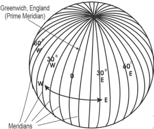
Figure 3.3 Meridians of Longitude
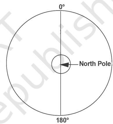
Figure 3.4 Meridians of $0^\circ$ and $180^\circ$ join at the North Pole
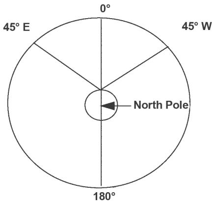
Figure 3.5 Drawing of Meridians of Longitude
Table 3.1 A Comparison between the Parallels of Latitudes and the Meridians of Longitudes
| S. No. | Parallels of Latitude