Chapter 4
Spatial Information Technology
You know that the computers enhance our capabilities in data processing and in drawing graphs, diagrams and maps. The disciplines that deals with the principles and methods of data processing and mapping using a combination of computer hardware and the application software are referred as the Database Management System (DBMs) and the Computer Assisted Cartography, respectively. However, the role of such computer applications is restricted to merely processing of the data and their graphical presentation. In other words, the data so processed or the maps and diagrams so prepared could not be used to evolve a decision support system. As a matter of fact, there are several questions that we normally encounter in our day-to-day life and look for satisfactory solutions. These questions may be: What iswhere ? Why is it there ? What will happen if it is shifted to a new location? Who will be benefited by such a reallocation? Who are expected to loose the benefits if reallocation takes place? In order to, understand these and many other questions, we need to capture the necessary data collected from different sources and integrate them using a computer that is supported by geo-processing tools. Herein lays the concept of a Spatial Information System. In the present chapter, we will discuss basic principles of the Spatial Information Technology and its extension to the Spatial Information System, which is more commonly known as Geographical Information System.
What is Spatial Information Technology?
The word spatial is derived from space. It refers to the features and the phenomena distributed over a geographically definable space, thus, having physically measurable dimensions. We know that most data that are used today have spatial components (location), such as an address of a municipal facility, or the boundaries of an agricultural holdings, etc. Hence, the Spatial Information Technology relates to the use of the technological inputs in collecting, storing, retrieving, displaying, manipulating, managing and analysing the spatial information. It is an amalgamation of Remote Sensing, GPs, GIS, Digital Cartography and Database Management Systems.
What is GIS (Geographical Information Sstem)?
The advance computing systems available since mid 197O's enable the processing of georeferenced information for the purpose of organising spatial and attribute data and their integration; locating specific information in individual files and executing the computations, performing analysis and evolving a decision support system. A system capable of all such functions is called Geographic Information System (GIS). It is defined as A system for capturing, storing, checking, integrating, manipulating, analysing and displaying data, which are spatially referenced to the Earth. This is normally considered to involve a spatially referenced computer database and appropriate applications software. It is an amalgamation of Computer Assisted Cartography and Database Management System and draws conceptual and methodological strength from both spatial and allied sciences such as Computer Science, Statistics, Cartography, Remote Sensing Database Technology, Geography, Geology, Hydrology, Agriculture, Resource Management, Environmental Science, and Public Administration.
Forms of Geographical Information
Two types of the data represent the geographical information. These are spatial and non – spatial data (Box 4.1). The spatial data are characterised by their positional, linear and areal forms of appearances (Fig. 4.1).
Box 4.1 : Spatial and non-spatial data
| Stock Register of a Cycle shop | Literate Population in States1981 | ||||
| Part No. | Quantity | Description | State | % Male | % Female |
| 101435 | 54 | Wheel SpokeBall Bearing | KeralaMaharashtra | 75.3 | 65.734.832.3 |
| 108943 | 68 | 58.8 | |||
| 105956 | 25 | Wheel Rim | Gujarat | 54.4 | |
| 123545 | 108 | Tyre | Punjab | 47.2 | 33.7 |
Geographic Database : A database contains attributes and their value or class. The non-spatial data on the left display cycle parts, which can be located anywhere. The data record on the right is spatial because one of the attributes, the name of different states, which have a definite locations in a map. This data can be used in GIS.
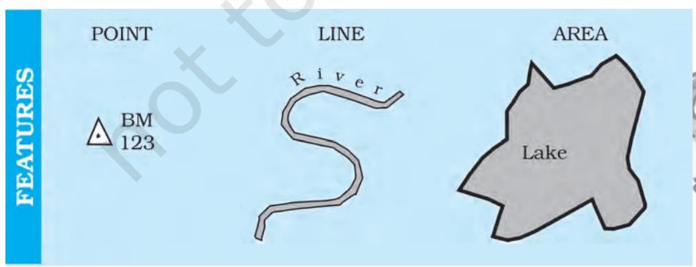 Fig. 4.1 : The Point, a Line and an Area Feature
These data forms must be geometrically registered to a generally accepted and properly defined coordinate system and coded so that they can be stored in the internal database structure of GIS. On the other hand, the data those describe the spatial data are called as Non-spatial or attribute data. The spatial data are the most important pre-requisite in a spatial or geographical information system. In a GIS core, it could be built in several ways. These are :
- Acquire data in digital form from a data supplier
- Digitise existing analogue data
- Carry out one's own surveys of geographic entities.
The choice of a source of geographical data for a GIS application is, however, largely governed by :
- The application area in itself
- The available budget, and
- The type of data structure, i.e., vector/raster.
For many users, the most common source of spatial data is topographical o1 thematic maps in hard copy (paper) or soft copy form (digital). All such maps are characterised by :
- A definite scale which provides relationship between the map and the surface it represents,
- Use of symbols and colours which define attributes of entities mapped, and
- An agreed coordinate system, which defines the location of entities on the Earth's surface.
Advantages of GIS over Manual Methods
The maps, irrespective of a graphic medium of communication of geographic information and possessing geometric fidelity, are inherited with the following limitations :
(i) Map information is processed and presented in a particular way. (ii) A map shows a single or more than one predetermined themes. (iii) The alteration of the information depicted on the maps require a new map to be drawn.
Contrarily, a GIS possesses inherent advantages of separate data storage and presentation. It also provides options for viewing and presenting the data in several ways. The following advantages of a GIS are worth mentioning :
- Users can interrogate displayed spatial features and retrieve associated attribute information for analysis.
- Maps can be drawn by querying or analysing attribute data.
- Spatial operations (polygon overlay or buffering) can be applied on integrated database to generate new sets of information.
- Different items of attribute data can be associated with one another through shared location code.
Components of GIS
The important components of a Geographical Information System include the following:
(a) Hardware (b) Software (c) Data (d) People (e) Procedures
The different components of GIS are shown in Fig. 4.2.
Hardware
As discussed in Chapter 4 the GIS has three major components :
- Hardware comprising the processing, storage, display, and input and output sub-systems.
- Software modules for data entry, editing, maintenance, analysis, transformation, manipulation, data display and output.
- Database management system to take care of the data organisation.
Software
An application software with the following functional modules is important prerequisite of a GIS :
- Software related to data entry, editing and maintenance
- Software related to analysis/transformation/manipulation
- Software related to data display and output.
Data
Spatial data and related tabular data are the backbone of GIs. The existing data may be acquired from a supplier or a new data may be created/collected in-house by the user. The digital map forms the basic data input for GIs. Tabular data related to the map objects can also be attached to the digital data. A GIS will integrate spatial data with other data resources and can even use a DBMs.
People
GIS users have a wide range from hardware and software engineers to resources and environmental scientists, policy-makers, and the monitoring and implementing agencies. These cross-section of people use GIS to evolve a decision support system and solve real time problems.
Procedures
Procedures include how the data will be retrieved, input into the system, stored, managed, transformed, analysed and finally presented in a final output.
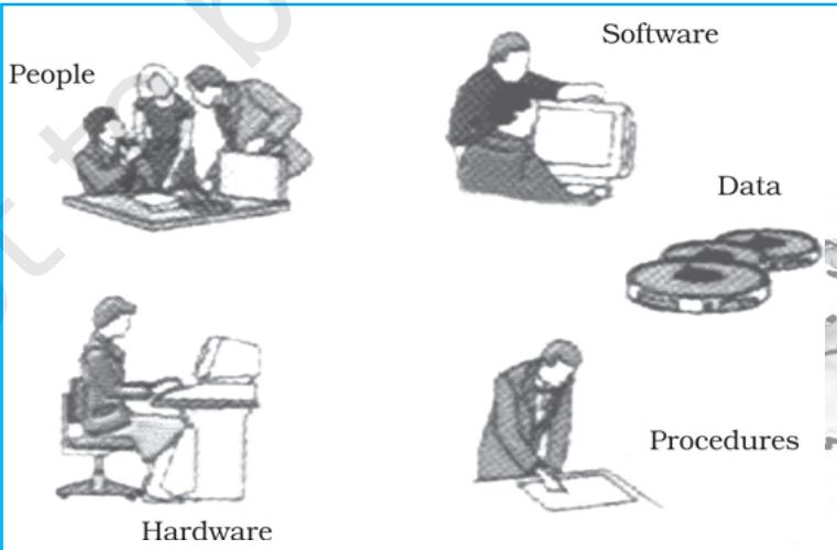 Fig. 4.2 : Basic Components of GIS
Spatial Data Formats
The spatial data are represented in raster and vector data formats :
Raster Data Format
Raster data represent a graphic feature as a pattern of grids of squares, whereas vector data represent the object as a set of lines drawn between specific points.
Consider a line drawn diagonally on a piece of paper. A raster file would represent this image by sub-dividing the paper into a matrix of small rectangles, similar to a sheet of graph paper called cells. Each cell is assigned a position in the data file and given a value based on the attribute at that position. Its row and column
 Fig. 4.3 : Generic Structure for a Grid
coordinates may identify any individual pixel (Fig. 4.3). This data representation allows the user to easily reconstruct or visualise the original image.
The relationship between cell size and the number of cells is expressed as the resolution of the raster. The effect of grid size on data in raster format is explained in Fig. 4.4.
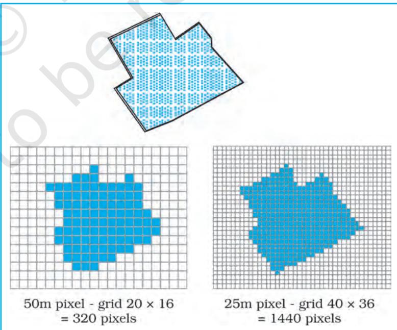 Fig. 4.4 : Effect of Grid Size on Data in Raster Format
The